


Handy GPS lite

Description of Handy GPS lite
Handy GPS is a navigation application designed for outdoor enthusiasts and adventurers. This app serves as a reliable tool for activities such as hiking, mountain biking, kayaking, and geocaching. Available for the Android platform, users can download Handy GPS to enhance their outdoor experience without the need for a user account or complicated setup.
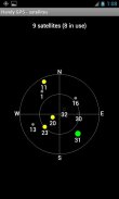
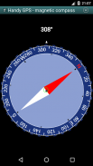
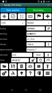
The primary function of Handy GPS is to utilize GPS technology for tracking and navigating in remote areas. This capability makes it especially useful for users engaging in outdoor sports, as it does not require network connectivity, ensuring that it works effectively even in isolated locations. The app allows users to operate with UTM or latitude/longitude coordinates, which can be particularly beneficial for those who prefer to use traditional paper topographic maps.
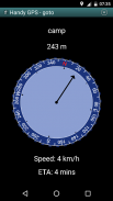
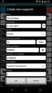
One of the app's notable features is its ability to store waypoints, which are specific locations that users can mark for future reference. However, the trial version of Handy GPS limits users to storing three waypoints and 40 track log points. This allows users to experience the application's basic functionalities before deciding to upgrade to the paid version for unlimited access.
In the paid version of Handy GPS, users gain access to a broader range of features. These include an unlimited number of waypoints and track log points, which can be advantageous for those who frequently venture into the outdoors. Offline maps are also available in the paid version, enabling users to navigate without relying on data connectivity. This feature is particularly useful in remote areas where signal strength may vary.
The app supports custom datums, which can help users work with different coordinate systems. Additionally, Handy GPS offers an elevation profile, allowing users to visualize the terrain they will encounter during their outdoor activities. This information can be crucial for planning hikes or rides, ensuring that users are prepared for the challenges ahead.
Handy GPS also incorporates multimedia capabilities, enabling users to take photos and record voice memos directly within the app. This feature allows adventurers to document their experiences and share them with friends or family. Furthermore, users can easily email or SMS their location to someone, providing a simple way to communicate their whereabouts during outdoor excursions.
The app includes UK grid references, catering to users in the United Kingdom and those who may require this specific navigation format. GPS averaging is another feature that can improve location accuracy, which is particularly beneficial in dense forests or mountainous regions where GPS signals may be obstructed.
Users can also access information about sunrise and sunset times, which is essential for planning outdoor activities around daylight hours. Handy GPS allows users to export waypoints and tracklogs to a CSV file, facilitating data management and sharing for those who wish to analyze their outdoor activities more closely.
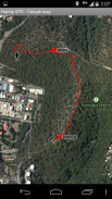
The app is equipped with tools to compute the length, area, and elevation change from the tracklog, providing valuable insights into the user's journey. This data can be useful for assessing the difficulty of a trail and planning future excursions. Additionally, the app can compute calories burned during outdoor activities, offering users a way to track their physical exertion.
Handy GPS requires several permissions to function effectively. It needs access to GPS for location determination, network access for standard map layers, and SD card access for storing waypoints and tracklogs. Camera access is granted for taking photos, while audio recording permissions are necessary for voice memos in the paid version. The app also prevents the phone from sleeping, which is crucial for ensuring that proximity alarms work correctly during activities.
For users who plan extended and remote hikes, it is advisable to carry a battery bank and an alternative navigation method, such as a paper map and compass. This precaution ensures that users have a reliable backup in case their mobile device loses power or encounters issues with GPS functionality.
In conclusion, Handy GPS is a practical navigation tool tailored for outdoor sports and adventures. With its array of features, including waypoint storage, offline maps, multimedia capabilities, and detailed tracking options, it serves as a comprehensive resource for enthusiasts exploring the great outdoors. Users can download Handy GPS to fully experience its offerings, whether they opt for the trial or the paid version.
Handy GPS lite - Version 42.8
(21-11-2024)
Handy GPS lite - APK Information
APK Version: 42.8Package: binaryearth.handygpsfreeLatest Version of Handy GPS lite
Other versions


 4.63
4.63


Apps in the same category


